Overview of county-based pesticide work with NYSDEC
Area selection within exposure assessment
Our work contributes to an exposure assessment which asks “how many people are exposed to ground water from private wells that contain what levels of pesticide residues”? Exposure assessment is a component of a larger risk assessment, which also applies information about the toxicity of the chemicals to which people are exposed. While our focus is on finding pesticide residues in the environment, we do compare our sampling results against applicable NY health and environmental standards for water (Division of Water TOGS 111). It is important to note that this assessment is not a search for accidental spills or illegal dump sites, but rather seeks to determine the level of pesticide residues in ground water that may result from label-compliant pesticide usage.
For exposure to happen, pesticide residues must be present at the same place and time as a well withdraws drinking water. We assume that the probability of finding residue presence and withdrawal for drinking together is higher when pesticide use intensity (more kilograms of leachable pesticide active ingredients used per square kilometer of land) and water use intensity (more wells per square kilometer) are elevated. Also relevant is what comes between the land surface where pesticides are used and the well at some depth below the surface: easily permeable soils and aquifers which may do little to inhibit movement and persistence of a pesticide are the most vulnerable sites for water contamination. Conversely, aquifers that are strongly protected from the surface by long travel distance and thick clay layers above the aquifer, and which experience limited recharge, should be least vulnerable. Finding consistently “clean” water samples from areas which we judge to be the most vulnerable serves as strong presumptive evidence that ground water in less vulnerable areas is also safe. This same general approach is used for selecting potential well sites within a study area.
We selected potential study counties by combining GIS-based maps of pesticide use and ground water use, as detailed below. In the first four counties (Cortland, Schenectady, Orange, and Cayuga) we focused almost solely on private wells because public supply systems are already required to test for certain pesticides. In Genesee County we were able, through the Genesee County Health Department which carried out sample collection, to include testing of a few small-scale regulated water supplies including restaurants and RV parks.
Pesticide Use
New York’s Pesticide Sales and Use Reporting system (PSUR) publishes data at the zip code level about pesticide product use and pesticide product sales. The sales data we select represents sales to direct agricultural users (farmers who apply their own pesticides) who are exempted from reporting each application to the PSUR. We map these data after converting to the active ingredient weight and dividing by the size of the zip code zone, to get a sense of use intensity. The atrazine map below summarizes 2000-2005 use plus sales data. The All AIs map below adds together all reported active ingredients.
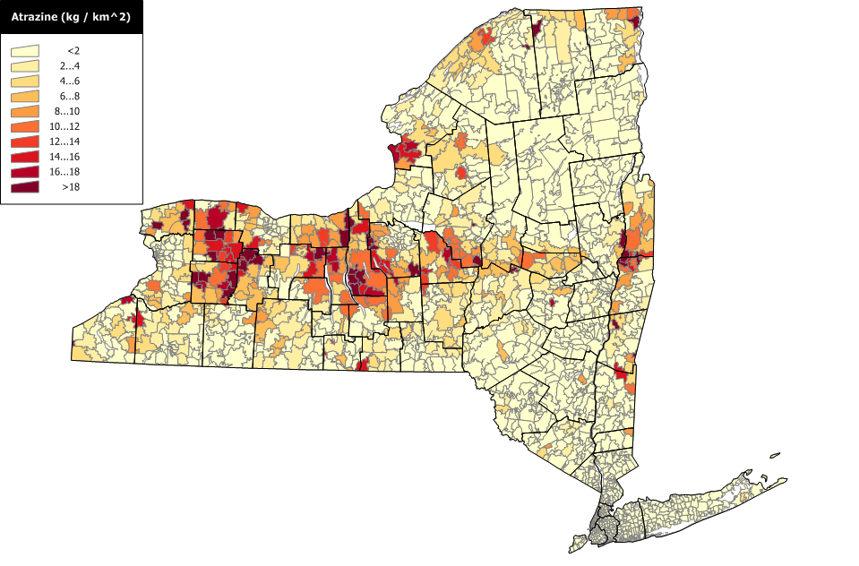 Atrazine use and sales intensity
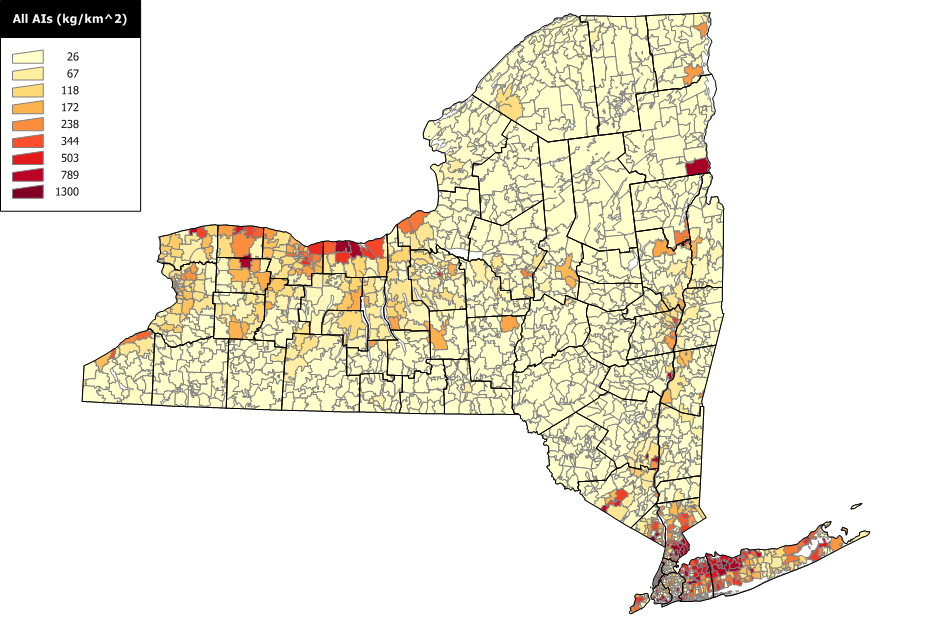 Summed active ingredients use and sales intensity
Many associate pesticides with agriculture. However, the heaviest pesticide use density in New York is actually in New York City and its metropolitan area:
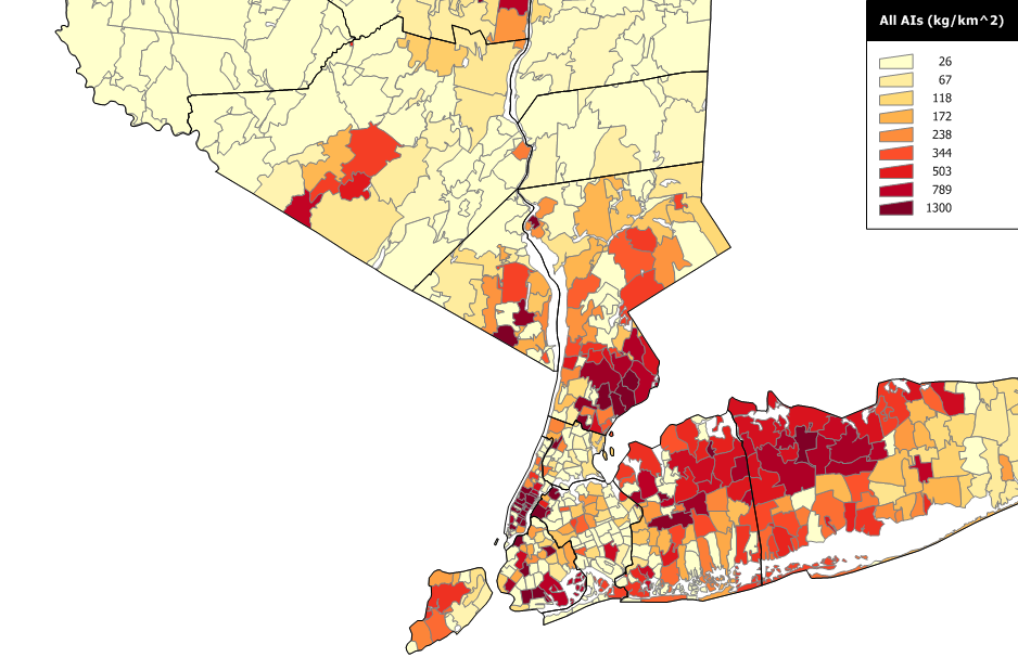 Summed pesticide use and sales intensity in New York City metro area
Pesticide Use Weighted for Mobility with Water and Persistence
USDA uses a Groundwater Ubiquity Score (GUS1) to evaluate the likelihood of different pesticides showing up and persisting in ground water. Leaving aside considerations of preferential flow, a pesticide that sticks to soil is less likely to move deeper to groundwater (however, it may be more likely to erode and show up in surface water). A pesticide that is easily degraded will not last long enough to show up in a distant well even if it is very mobile. Persistence and mobility properties are represented by the pesticide’s in-soil half life (degradation rate) and organic carbon partition coefficient (Koc, which reflects how strongly the pesticides absorb to orangic matter present in soil) respectively.
USDA has organized such data for use in the WIN-PST screening software, which includes the Pesticide Properties Database (PPD2). The diagram below shows several pesticides using PPD values of their persistence and mobility properties, together with the GUS categories (color curves). Those in the upper left corner (long-half life, low Koc) are the most mobile and longest-lived and thus have the highest GUS scores. Like the pesticides still contaminating the Long Island aquifers, these represent the greatest for long-term presence in groundwater. Moving down (shorter half-life) and/or to the right (less mobility) reduces the GUS.
When pesticide sales + use data are weighted for active ingredient GUS scores (giving greater weight to those with high GUS), the immobile and easily degraded substances are de-emphasized; the resulting maps thus provide a better guide for where to sample for those pesticides more likely to show up in groundwater. Statewide and western New York GUS-weighted maps of the intensity of pesticide usage follow:
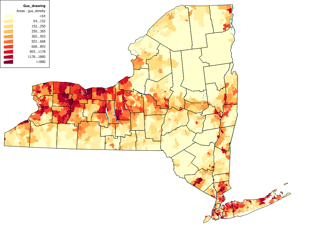 Pesticide use+sales weighted by Groundwater Ubiquity Score
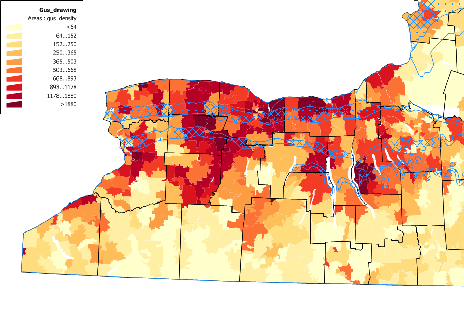 GUS in western NY
Aquifers and Ground Water Use
New York’s heaviest ground water use is from our “primary” water supply aquifers, which consist of unconsolidated glacial outwash and alluvium. These aquifers serve several million people via public water supply systems, particularly on Long Island including Queens of New York City. The upstate primary aquifers are in major river valleys such as the Susquehanna, Chemung, and Mohawk. Our smaller river and stream valleys often host “principal” aquifers in their floodplains, the difference between “primary” and “principal” being that the latter are not as heavily used for water supply.
Unconsolidated aquifers with shallow water tables and carbonate aquifers at the surface with thin soils above them are more vulnerable than deeply buried bedrock aquifers.
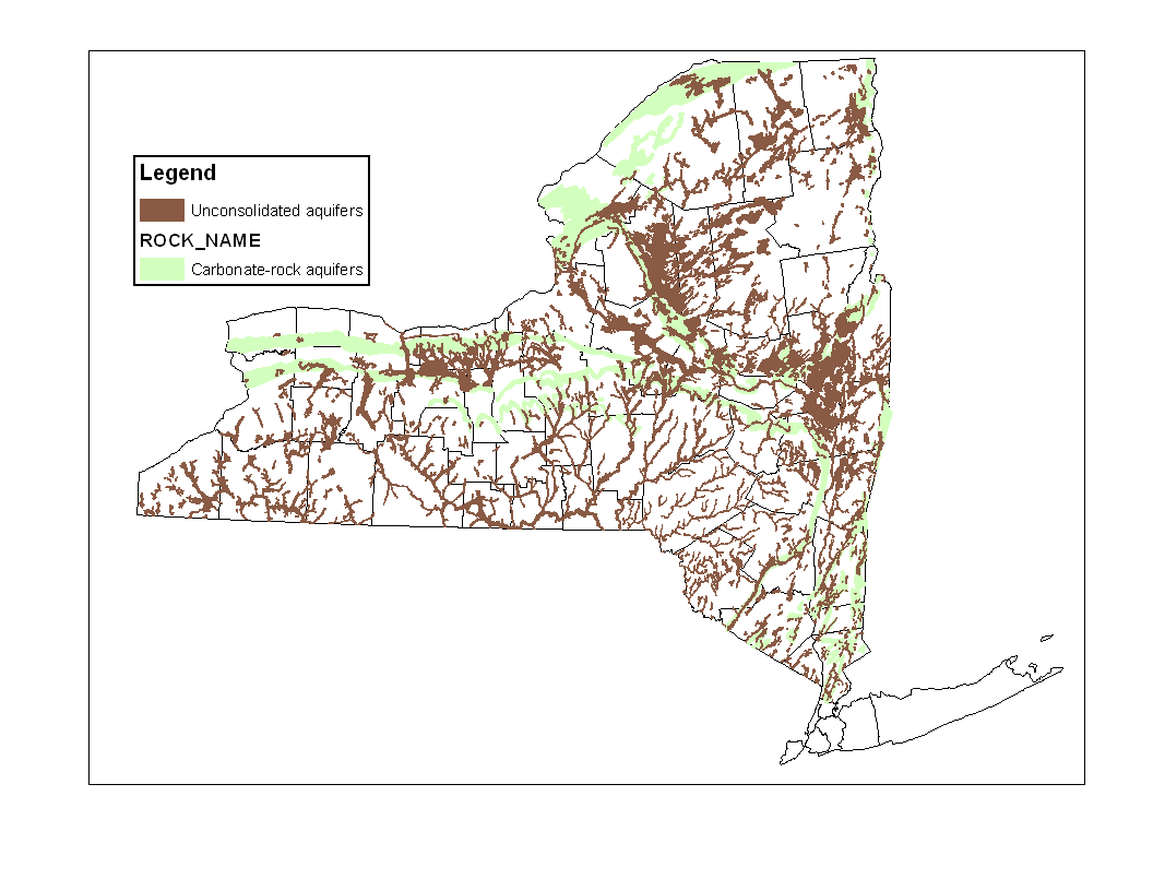 Upstate NY unconsolidated and carbonate aquifers
Our domain is private wells. Unfortunately the US Census stopped asking about household water supply sources, and we are thus forced to rely on 1990 data for mapping (below). The densest 1990 population using individual wells was in the lower Hudson valley, in Orange, Putnam, Ulster, Dutchess, and northern Westchester Counties.
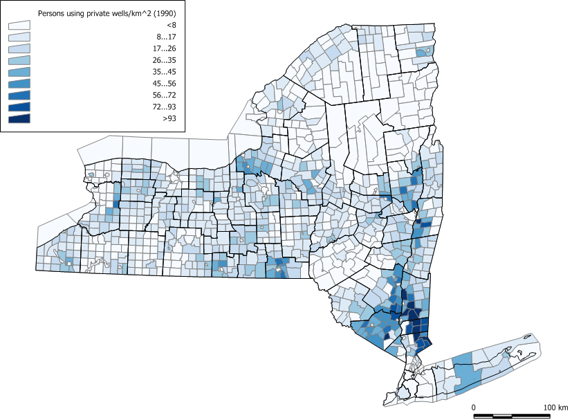 Private well water use map from 1990 US Census
The county projects were in Cortland, Schenectady, Orange, Cayuga, Genesee and Wayne Counties.
First sampling and later resampling
We collected one sample per site in each of the six counties originally. We returned to collect additional samples at selected sites in five of the six counties, omitting only Schenectady. Most of the return sampling was multiple samples per year per well in different seasons, to verify that we were not missing higher concentrations simply because of sampling at a time of year when no pesticide residues were passing.
Original County sampling was done by a mix of Cornell, County Soil and Water Conservation District, and County Health Department Personnel. County resampling was done by Cornell and County Soil and Water Conservation District personnel.
Last updated 2023-09-21 sp17 AT Cornell.edu.
Footnotes
Gustafson, D.I. 1989. Groundwater ubiquity score: A simple method for assessing pesticide leachability. Environmental Toxicology and Chemistry 8:339-357↩︎
Wauchope, R. D., T. M. Buttler, A. G. Hornsby, P. M. Augustijn-Beckers, and J. P. Burt. 1992. The SCS/ARS/CES pesticide properties database for environmental decision making. Reviews of Environ. Contamin. Toxicol. 123:1-155.↩︎