This is the first page at Level 1 in a three-level web. It introduces the 2021-2025 upstate New York pesticides in water project.
Navigate: ▲ Abstract | ► 2: Sites and protocols.
1: Introduction (Level 1)
1.1 Involvement: Voluntarism and confidentiality
The project relies on confidential cooperators who allow Cornell personnel to sample from wells and other environmental water access points on their properties. The privacy of the confidential cooperators is highly protected under Cornell’s contract with NYSDEC, thus nothing about the identity or specific locations of confidential cooperators will be released to NYSDEC or the public. (The cooperator is free to disclose their involvement.) As a result, any release or publication of data (such as in reports or this website) will include only anonymized and location-blurred data.
The project has also relied on a small cadre of volunteers who carry out sampling of lakes with Cornell’s assistance. These lake sampling volunteers are prominent locally and part of the CSLAP program thus have lesser need for anonymity, but nevertheless have the choice about release of project data to the public.
NYSDEC and Cornell are grateful to the confidential cooperators and lake sampling volunteers.
1.2 Prior work
The Cornell team (in cooperation with County Soil and Water Conservation Districts) has previously conducted sampling studies of upstate private wells in six counties (Figure 1), in chronological order: Cortland, Schenectady, Orange, Cayuga, Genesee, and Wayne) for NYS DEC, yielding single time-point data for around 240 wells. Cornell later revisited selected wells in some of these counties with seasonal sampling for a year or longer. In addition to annual reports to NYS DEC describing this work (available at this link) several peer reviewed papers covering this work have been published (Richards et al., 2012 1; Sinkevich et al., 2005 2). One focus in Genesee County was sampling wells in a karst (carbonate bedrock) area, where groundwater in karst-related fissures is vulnerable to rapid contamination from the surface, including the entry of water via sinkholes in fields and streambeds.
In related work, our research group studies how the ubiquitous herbicide glyphosate moves in the environment, with most emphasis on migration to surface water from wetness-prone sites (Richards et al., 2018 3).

One earlier NYS DEC/Cornell project sampled four lakes (Figure 2) in one round and later returned to two of the lakes (Lake Waccabuc, Sleepy Hollow Lake) in a second round (Figure 2).

1.3 Project objectives, priorities, and coverage
As noted above, NYS DEC wants to ensure that excess levels of pesticides (or their degradation products) are not migrating from their sites of application to groundwater and other water resources. Given that our prior years of work with NYS DEC had sampling sites that were primarily (although not exclusively) influenced by nearby field crop systems (corn and/or soybeans) and their herbicides, the primary focus of the current 2021-2025 project is on other land uses that involve differing pesticides and cultural practices.
These sites – termed categorical sites since their selection was based on categories of land use and corresponding pesticide use. These are multi-well sites where the priority is to sample upgradient, downgradient, and in some cases, within the area of application. Existing wells (or in some cases, groundwater-fed springs or ponds) are supplemented with shallow monitor wells installed by the Cornell team. These categorical sites are sampled twice annually and represent about 80% of the annual project sampling load.
Supplementing these are long-term sites primarily representing single wells which are sampled annually. In a number of cases, these are sites that have been carried over from prior sampling projects – some dating 20 years since we first sampled them – and thus provide a longer timespan of sampling record. These represent ~15% of the annual sampling load.
Finally, representing about 5% of the annual sampling load are four lakes that are sampled annually or semiannually at inlet, outlet and mid-lake positions.
In terms of overall progress, Year 1 (2021) was mainly preparation for the project including building a geographic database and developing a recruitment strategy. In 2022 we recruited most of our categorical groundwater cooperators and lake volunteers, installed additional shallow wells where needed at the categorical sites, and began sampling at categorical and lake sites. Recruitment of the long-term sites, a lower priority, began in 2023 and sampling of them began alongside the second year of sampling of categorical and lake sites. By the end of 2023, the project recruited all of its final cooperator roster. Initial analytical data interpretation began with the return of pesticide results for 2022 samples from the NYS DEC Air Toxics Laboratory in early 2023 then continued with the results of testing 2023 samples in 2024. Sampling for 2024 continues.
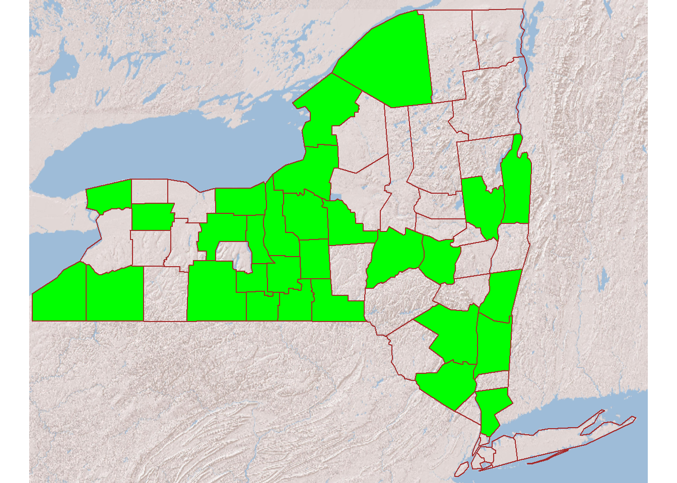
The upstate project has reached 28 counties (Figure 3), with an intentionally diverse coverage that allows monitoring of a broad range of conditions that could affect the environmental fate of pesticides. We do not expect to encounter many cases of upstate conditions as vulnerable to groundwater contamination as much of Long Island has proven to be. The sensitivity of modern lab techniques guarantees that we will detect some residues – especially breakdown products – of certain popular chemicals at very low levels, as we did in earlier Upstate work. The 2022 results included the herbicide metolachlor’s breakdown products at several sites, at concentrations far below levels of concern. These earliest results confirm that many of our monitoring points and sampling techniques are working as intended.
The project proceeds as outlined in the diagram below:
graph LR;
   A((recruited<br>groundwater<br>owners))-->B[Cornell<br>installs wells<br>if needed]
   B-->C[Cornell<br>samples<br>from wells<br>and lakes]
   A-->C
   H((recruited lake<br>volunteers))-->E[Volunteers<br>sample<br>from lakes]
   C-->D[DEC and Cornell<br>analyze<br>chemistry]

   E-->D
   D-->F[Cornell<br>interprets<br>and reports]
   F--anonymized_data-->G((Public-web))
   F--anonymized_data-->I((NYSDEC))
   F--full_site<br>groundwater_data-->A
   F--full_lake_data-->H
Navigate: ▲ Abstract | ► 2: Sites and protocols
Last updated: 2024-12-09, sp17 AT cornell.edu
Footnotes
Richards, Brian; Pacenka, Steven; Salvucci, Anthony; Saia, Sheila; Whitbeck, Luanne; Furdyna, Peter; Steenhuis, Tammo. (2012). Surveying Upstate NY Well Water for Pesticide Contamination: Cayuga and Orange Counties. Ground Water Monitoring & Remediation. 32. 73 - 82. https://doi.org/10.1111/j.1745-6592.2011.01366.x.↩︎
Michael G. Sinkevich Jr, M. Todd Walter, Arthur J. Lembo Jr, Brian K. Richards, Natalia Peranginangin, Sunnie A. Aburime, Tammo S. Steenhuis. A GIS-Based Ground Water Contamination Risk Assessment Tool for Pesticides. Groundwater Monitoring and Remediation, 2005. https://doi.org/10.1111/j.1745-6592.2005.00055.x↩︎
Richards, Brian; Pacenka, Steven; Meyer, Michael; Dietze, Julie; Schatz, Anna; Teuffer, Karin; Aristilde, Ludmilla; Steenhuis, Tammo. (2018). Antecedent and Post-Application Rain Events Trigger Glyphosate Transport from Runoff-Prone Soils. Environmental Science & Technology Letters. 5. https://doi.org/10.1021/acs.estlett.8b00085.↩︎