Methods detail - site characterization
We characterize categorical sites in some detail to be able to link pesticide uses to residue condentrations in wells.
1. How deep is the groundwater?
This is a screening criterion for a site. If there are no suitable wells, Cornell’s temporary wells are limited to a depth around 25 feet under the most favorable site conditions. A water table deeper than that can rule out a site.
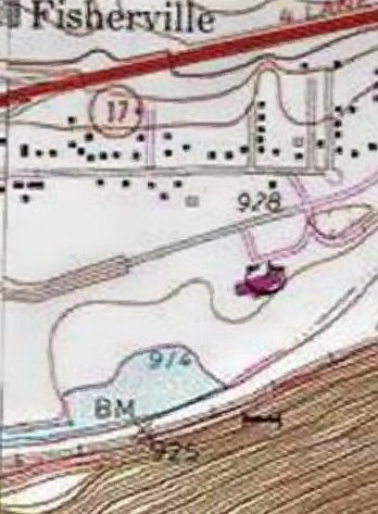
Groundwater in Upstate NY emerges to a stream, ditch, or pond in most circumstances. A water table pond is a solid clue to depth of the water table. Topographic maps can help. For example the pond in Figure 1 at the hamlet of Fisherville near Horseheads, NY had a water elevation of 914 feet above sea level, and there is a geodetic benchmark (“BM”) at 925 near its south shore. The 920 contour is between the pond and benchmark. Ponds in this area were typically gravel excavations, and fill with water to the water table, rising and falling with the seasons. Thus the land along the south shore had a depth on the order of 6 feet at the time the map was produced.
Recent LIDAR maps are even more helpful. Topographic maps can be decades out of date, where the LIDAR map is recent. Their contour interval in New York seems to be no finer than 10 feet. LIDAR maps have a much higher vertical resolution than topographic maps. They show a “hole” where there was standing surface water, but elevation data at a shoreline can give a reasonable proxy for the water level.
The LIDAR image in Figure 2 demonstrates how this can work, with a larger water table pond, but a smaller pond can also work.

Redder is higher, brownish is lower.
Light brown along the rim of the pond is around Z=271.2 meters. The road reads at Z=274.1 meters. The pond water surface has no LIDAR data so the aerial photo basemap shows through. Thus the water table was about 3 meters below the road at the time of overflight. This pond has a spillage outlet but there was no water at the time of the image.
2. Where does the groundwater flow?
Shallow groundwater flows downgradient (from higher water table to lower water table) just like surface water flows downhill. In an unconfined (water table) surficial aquifer the direction will be toward the “drain”, a pond or ditch or stream. The general direction follows the trend of the topography unless there are barriers to flow, heavily pumped wells, or artificial point recharge such as a stormwater basin.
Subsurface tile drains can alter the direction somewhat. One cooperator split a field in half and installed drains that slope southwestward in one half and northeastward in the other half toward respective field edges. There are perimeter ditches along both edges. Thus there is a groundwater divide under the field like a topographic ridge, created by the slopes of the tile drains.
Digging ditches to below the water table can make a difference. We look for standing or flowing water in ditches. Aside from during storms, the water table at the ditch slope will be a little higher than the level visible in the ditch.
3. Where and when are pesticides used?
Owner permitting, we wish to learn where, when, and which pesticides are used. It may take a while for the owner to become confident in sharing this information with Cornell. It helps to be able to guarantee confidentiality from NYSDEC inspectors.
4. Where are the points to draw water samples?
The potential points to measure include:
- existing shallow wells, for example irrigation wells (must tap the surficial aquifer, not a deeper layer)
- water table ponds that do not receive much surface runoff; and
- temporary wells we install for the project.
Any points where we sample are agreed in advance with the owner or their senior representative, particularly if we install temporary wells.
We record the latitude and longitude positions of each sampling point, including for any one-time-samples. This goes in our confidential site GIS file set.
The sampling points are numbered within the site, for example site Nur-3 has four sampling points:
- “well-potable” is a drinking water well also used for irrigation;
- “upgradient” is a groundwater fed pond, used for irrigation, downhill from a neighboring property that grows field crops;
- “Well-1” is a temporary Cornell well installed in the middle of a field downhill from where the nursery operation recharges its open and closed greenhouse drainage water (no pesticides are used on the field);
- “Well-2” is a temporary Cornell well in the trees at the downgradient edge of the same field. There is a headwater stream flowing through this zone, clearly discharged groundwater.
Thus to specify the sampling point within the entire project, we specify the site ID together with the sampling point ID. We use these non-disclosing identifiers with NYSDEC and when reporting to the owner.
We provide to the owner a sampling point map, on aerial photo base, when we report analytical results.
Last updated 2023-08-17, sp17 AT cornell.edu.