graph LR;
A[L1: this page overview of methods]-->B1[L2: details analytical]
A-->B2[L2: details sampling]
A-->B3[L2: details monitor wells]-->B3a[L3: HowTo<br>installing monitor wells]
A-->B4[L2: details groundwater<br>site characterization]-->B4a[L3: HowTo site characterization]
A-->B5[L2: details gis]-->B5a[L3: HowTo gis mapping]
A-->B6[L2: details database]-->B6a[L3: HowTo tabular database]

B1-->B1a[L3: HowTo<br>ion chromatograph anions]
B1-->B1b[L3: HowTo<br>inductively coupled plasma cations]
B1-->B1c[L3: HowTo<br>sampling including<br>field measurements]

B2-->B2a[L3: HowTo<br>sampling from monitor wells]
B2-->B2b[L3: HowTo<br>sampling from owner wells]
B2-->B2c[L3: Howto<br>sampling from ponds]
B2-->B2d[L3: HowTo<br>sampling from lakes]
B2-->B2e[L3: HowTo storing samples]
B2-->B2f[L3: Howto acidifying for cations]
Sampling, analytical and data methods
There are three levels of project methods detail available online:
- This page contains a broad, very summarized overview;
- There are more detailed summaries of certain facets in second level pages linked from some parts of this page; and
- There are specialized HowTo documents that we use to plan and record experience, linked from this page or from the second level pages.
Level 3 HowTo documents are not written for cooperators or the general public. They may be useful to technical professionals.
Map of methods pages:
1. Determining where to recruit
NYSDEC hoped for a diverse array of sites that would have several different purposes of pesticide use (such as indoors versus outdoors, food production versus turf management), different hydrogeologic and climatic settings with an emphasis on greater pesticide leaching likelihood, and above average pesticide use. Not all of these criteria could be satistified together, but the arrays recruited are certainly diverse, reflecting Upstate New York’s patchwork of many kinds of urban and rural characteristics. Upstate New York has 133,000 km2 of area and a diagonal distance of 613 km.
1.1 Categorical sites
Cornell SWL needed to recruit over 20 categorical sites, which would meet several NYSDEC criteria. The owners needed to be bold enough to allow groundwater sampling close to their pesticide uses for several years, indirectly involving a regulatory agency. There were thousands of candidates in some categories, barely a dozen in one category. We began by making maps using Google Earth searching (see categoricals detail), specialty business directories and other web sources. We did several no-contact reconnaissance trips in 2021 while there were Covid contact restrictions affecting both Cornellians and certainly inhibiting potential cooperating small businesses from meeting with us to consider cooperation. These recon trips also helped to scout future sampling routes.
Cornell and Cornell Cooperative Extension networking (particularly in the golf, sod, greenhouse, vineyard and farming industries) and Cornell SWL staff friendships with small businesses reached the first ten recruits whose properties also looked promising on maps that combined hydrogeology with category presence. Later recruits without pre-existing connections required much more legwork and communication work. Around half of those we approached were willing. A small number did not have the mindset (including self confidence) to work indirectly with regulator NYSDEC despite confidentiality assurances; however some already had very cordial relationships with NYSDEC. A few were interested but concerned about “what if they find something?” Some were bureaucratic requiring multiple levels of approval and needed to invoke lawyers, a chilling prospect including within Cornell. Some were simply too busy to be reachable beyond an initial ice-breaking contact.
One instructive failure to recruit had a willing owner but we discovered that soil and surficial geology maps of their site had failed to reflect that several feet of the site’s surface layers were “scalped” after the soil map was developed. Thus there was no samplable shallow groundwater, just an originally deeper clay layer! New York State’s surficial geology maps and USDA soil maps have otherwise proved very representative and helpful to match candidate sites against NYSDEC criteria.
The categories expressly exclude field crops (alfalfa, livestock corn) which had been thoroughly covered by earlier work.
1.2 Long term
The long term sites represented only one sixth of the data flow of the project (24 samples per year compared to a target 144 from categoricals), thus had an inherently lower priority. To fit into available labor, we began long-termer recruitment during the sixth project quarter (fall 2022) and found the first cooperators in early 2023. The array is almost filled by summer 2023.
We identified candidates in various ways. We began by recontacting owners whose wells Cornell sampled in earlier work with NYSDEC. A few were willing but contact became difficult with some earlier participants and the earlier participants were not chosen according to the current project’s criteria thus many were ruled out before attempting contact. In particular a deep bedrock well is essentially useless in the project because the recharge area will be practically undiscoverable thus any pesticide detections could not be connected to any knowable pesticide use.
Next we used reconnaissance and drop-ins productively in Jefferson and St. Lawrence Counties where we had not worked before; this further diversified the overall project spatially because we had not gained any categorical sites in that Upstate region.
We continued trying with earlier participants and then reached into three new small business types: arboretums, hops farms, and licensed cannabis farms. The latter two are emergent types of small-scale Upstate farming that involve many small businesses of the kinds that proved willing to join as categoricals. Hops was once a vibrant industry in New York but had some major disease problems and the impact of alcohol Prohibition. Cannabis crops and products also suffered from a more recent Prohibition, now in the process of major reform nationally and in New York. We gained four cooperating cannabis farms as long term sites, including one organic farm with pesticide using neighbors, quickly. We continue to look for a hops farm.
We again evaluated candidates based on map overlaying, especially aerial photography, soil, and surficial geology maps. We needed to relax criteria toward the bare minimum – shallow groundwater on site preferably with an existing well, some nearby pesticide use, and willingness to allow Cornell to sample for a few years.
1.3 Lakes
Upstate New York has hundreds of internal lakes of sizes tiny to enormous Oneida Lake and the Finger Lakes. Well over 100 lakes have volunteer groups already affiliated with the NYSDEC Division of Water under the Citizens’ Statewide Lake Assessment Program (CSLAP) and already taking samples.
Lakes for this project were chosen based on minimum effort to recruit, again because of a very small sample quota per year, just 8 samples initially. We considered about a dozen lakes from ones where we could make direct contact with volunteers or ones where Cornell could sample ourselves. Distance from Ithaca was a consideration for our own sampling. We ended up with two easily willing lake volunteer groups and two lakes to be sampled by Cornell personnel. These are geographically spread out. We again applied the categorical pesticide user maps mentioned under 1.1 to ensure that there were some categorical pesticide users in each watershed.
1.4 Confidentiality of categoricals and long term identities and locations
Except for the lake volunteers who are formally affiliated with the NYSDEC Division of Water, all cooperators in the project are considered confidential and their identities are not known beyond the immediate Cornell work group who carries out most of the project. This is a long-standing provision in Cornell’s contracts with the DEC Bureau of Pest management, strengthened in the 2021-2025 contract. This also makes the any data about the sites immune to Freedom of Information requests, similarly to the proprietary information that NYSDEC and Cornell handle in other contexts when working with businesses and households.
1.5 Second level GIS detail: GIS
2. Categorical groundwater site characterization
Initially during discussions with a candidate owner, then well selection or installation, and later when interpreting sampling results, it is important to understand as well as feasible the following aspects of a site:
- directions of shallow groundwater flow
- depth to groundwater
- where pesticides are applied indoors and outdoors, with potential escape routes for indoor-applied pesticides
- timing of pesticide use
We do not do formal characterization of long term sites because of the minimal number of samples to be collected at a site, perhaps only three.
2.1 Background data
Modern publicly available GIS maps include digital aerial photos, in visible colors and false color-infrared, scanned USGS topographic maps, NRCS soil surveys, land cover maps derived from satellite imagery, property tax maps, surficial geology maps, and many other geographic items that are capable of being overlain (with care to take account of the data strengths and weaknesses). LIDAR high resolution topographic information is unevenly published for New York as of 2023, but avaiable for most areas we found useful to scan for candidates. Together these kinds of public geographic information, incorporated into site-specific GIS files printed to take into the field, proved highly valuable when visiting a site for the first time.
Aerial photos are particularly useful to determine which parts of a site house greenhouses, cropped fields, and drainage paths.
A telephone call or email with an owner before the first walkaround sometimes adds information about where there are existing wells, and where pesticides are actually used. This is more likely to come during walkaround with an owner or their representative.
In a few cases we have been able to identify nearby wells registered with NYSDEC Division of Water, which have available driller stratigraphic logs that give insights below the land surface. NYSDEC publishes the locations of all registered wells in a GIS format and makes available the driller logs via Freedom of Information requests.
2.2 Inferring groundwater flow directions
In many upstate cases, shallow groundwater escapes to surface water rather than recharging a deeper aquifer. There is much more annual precipitation than annual maximal (potential) evapotranspiration in all parts of New York, except in deepest drought years. (There can be seasonal water deficits in summers.) Thus the first clue about shallow groundwater flow directions is to look for the nearest surface water bodies – streams, ponds, ditches; natural or artificial. Topographic maps, especially recent ones based on LIDAR imagery, are strong clues.
Unless a pond is “perched” by an impervious lining such as tight packed clay, the water level probably reflects the local water table. (One cooperator has perched ponds.)
Tile drainage within a site can influence groundwater flow directions; typically this will follow surface topography.
Glaciers, both their effect on reshaping the land surface and the impact of their melting progress during recession, complicate upstate surficial geology profoundly.
This level of information requires experienced Cornell personnel to walk around the site with an owner representative. SWL has three personnel each with over 40 years of experience working in Upstate NY on hydrology, at scales from counties (NYSDEC Long Island and Upstate Groundwater Management Program development in 1980s) to individual rural properties.
2.3 Pesticide use patterns
Advance information from aerial photo interpretation can often narrow down areas of pesticide use on a property. Vegetation of different types, buildings, roads, drainage ditches, streams, ponds and other relevant features are easily discernable.
The types of pesticide-using activity on a site are determinable primary from the owner, but there are advance information sources about their category of activity. For example, there is Cornell research-based guidance about pest problems and their management for greenhouses, golf courses, vegetable farms, vineyards, and other user categories. The advance material helps to understand what questions to ask the owner.
Some owners have been kind enough to provide lists of pesticide products used during or following initial walkarounds. Some recited all significant products while we walked around. This can be the most intrusive aspect of Cornell’s relationship with the site owner so we must be cautious about when to bring this up.
For 2022, none of the pesticide residues detected in water from any site is a surprise, i.e. all detections match products labeled for use in that kind of site. There is even an excellent match to product lists for those sites already providing them.
We sometimes learn about pesticide use timing by having to schedule a sampling visit around a pesticide application. We must not enter a treated area for water sampling until after the product label allows re-entry.
2.4 Second level detail: site characterization
3. Installing monitor wells
While there are many wells installed in upstate New York, registered since 2000 and in a public database, very few of the registered wells are suitable for monitoring the leaching of pesticides, which requires a shallow well and not too heavy pumping so that most of the recharge reaching the well is from the pesticide user’s own property.
Cornell installs temporary small diameter (1.25 inches) wells up to 25 feet deep using a powered screw auger, and we drive in shallower wells using a manual well pounding hammer.
3.1 Driven wells
Driven wells are all galvanized steel except for an iron screw-on cap; these are typically used for potable water wells. They have a screened bottom section about 3 feet long, and solid pipe for the rest of the length (Figure 1). The screened section has a point at its lower end. Consecutive sections are threaded and screw together with drive couplings. The threads in the couplings are sealed with potable-grade pipe dope.

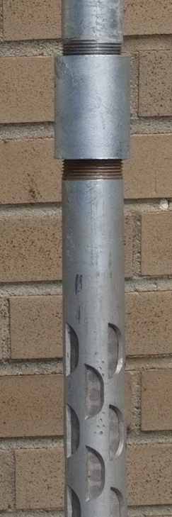
Ideally the well should have the entire screen below the water table during a dry season of a dry year, so that there is sufficient water to sample.
3.2 Augered wells
For wells that need to be deeper, instead of driving for the full length, we make a screw-auger hole first. Our 50 year old augering trailer worked great for this application.
(missing Figure: Giddings powered auger)
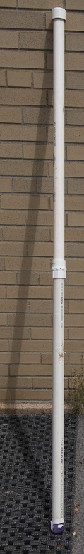
When possible we use a PVC well (Figure 3), since plastic will interact with fewer solutes. Notably glyphosate will attach to iron and aluminum oxides. The PVC well has horizontal slots 0.01 inches in width for water to enter (Figure 4).

3.3 Second level detail ==> Monitor wells
4. Sampling
4.1 Temporary monitor wells
We sample our temporary wells with a peristaltic pump. It can lift water about 25 feet given suitably stiff hose.

Since a monitor well is never pumped except while we are sampling, we let the water run for a few minutes, until our electtical conductance, temperature, and pH measurements stabilize.
Hoses are rinsed inside and wiped outside with deionized water after each use, to avoid carrying over any liquid from one sample to the next.
4.2 Owner wells
We typically sample an owner’s well from a tap that draws water before any owner treatment, such as softening. One owner installed for us a little vertical tube and the pump pushes the water up over the rim, giving a beautiful mushroom effect! Owner wells are typically used frequently during the growing season, so we usually do not have to let the water run for long before we can draw the sample.
A few owner wells have no pump of their own. We treat these like our temporary wells and use our peristaltic pump with our hose.
4.3 Groundwater-fed ponds
A pond that has no inlet but which has water in it most of the time is typically just a surfacing of the local water table; it may have an outlet. This is a relevant place to sample “groundwater”, as long as it has not rained too recently to dilute the recently-former groundwater.
We sample using our peristaltic pump and a hose that we dangle below the pond surface using a rod with a float near the end. Alernatively we use a cup on a rod.
(missing Figure: Peristaltic pump sampling arm for pond shores.)
4.4 Lakes
Lake volunteers and Cornell staff sample three of the project lakes using a Kemmerer cylindrical sampler. It is open with water flowing through it as it is lowered on a rope, then a “messenger” weight is sent down the rope to trigger closing the top and bottom of the sampler. Thus it gets water at a desired depth. By convention we sample starting 1.5 meters below the surface; optionally a deeper sample can be collected if the lake is unusually deep and perhaps thermally stratified.

Cornell personnel sample the fourth lake inlets and outlet from bridges using the Kemmerer or a peristaltic pump and hose, depending on water depth.
4.6 Second level detail ==> sampling
5. Analytical
5.1 Field measurements
| Apparatus | Picture |
|---|---|
| We measure the depth to groundwater when possible. This uses a “sounder” that consists of a graduated cable that we dip into the well. The cable reel at the surface beeps when the weighted probe at the end of the cable touches water. We then read off the graduations against the upper rim of the well. | 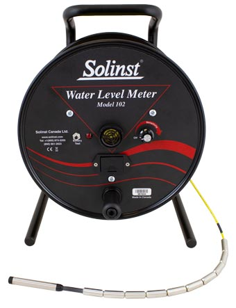 |
| We use a Hanna hand-held meter to read properties of water that the pump brings up, periodically while we pump. These properties include electrical conductance (EC), pH (acidity), and temperature. | 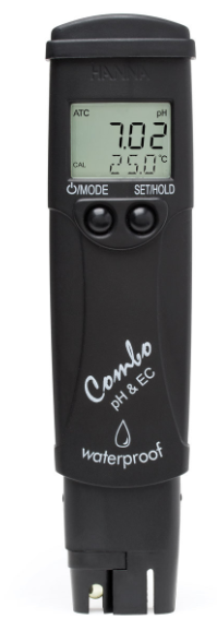 |
Measurements go into a field logbook before being transcribed into the project’s tabular database (section 6 of this page).
5.2 Cornell lab measurements
| Apparatus | Picture |
|---|---|
| We measure Alkalinity with a handheld meter to help determine bicarbonate and carbonate ion contents. This is part of the major cations and anions balance. | |
| We measure Anions (negative ions) including chloride, nitrate, phosphate, and sulfate using an Ion Chromatograph. This testing is done by SWL personnel at the USDA Plant Soil and Nutrition Lab on the Cornell Ithaca campus. | |
| We measure Cations (positive ions) including sodium, potassium, calcium and many others using an Inductively Coupled Plasma machine. Early testing was done in the Cornell Nurtient Analysis Lab (CNAL) and later testing is done at USDA’s Plant Soil and Nutrition lab on the Cornell Ithaca campus. |
We also use the Hanna EC/pH/temperature meter in the lab.
Measurements go into a lab logbook before being transcribed into the project’s tabular database (section 6 of this page).
5.3 DEC lab measurements
DEC’s Pesticide lab is part of the DEC Division of Air administratively but the lab is dedicated to pesticides in any medium. There is a wide array of equipment available. Most pesticide tests have been done using one machine.
| Apparatus | Picture |
|---|---|
| Liquid chromatograph with tandem mass spectrometer | [ ] picture of LC-MSMS |
| Gas chromatograph | [ ] picture of GC |
5.4 Second level detail ==> Methods detail - analytical
6. Database
6.1 Objectives
The project’s tabular database contains all measured data from field and lab, and descriptions of wells, samples, and sites. The data help to prepare reports for uploading to NYSDEC’s EQuIS system, summaries for quarterly and annual reports to NYSDEC, and detailed reports to confidential cooperators and lake volunteers.
The database is confidential because it contains the exact locations and contact info for the confidential cooperators.
In particular the database is structured around EQuIS submissions and interpretation. EQuIS mandates particular encodings and metadata that describe the data, so that data reusers in NYSDEC know plenty of context for each item in that database. Anything that hints at the specific location or identity of a confidential cooperator is very blurred or omitted while making excerpts for submission to EQuIS.
More detail ==> Methods detail - database
7. Quality assurance
US EPA mandates that States pay due attention to the quality of enviromental data that they collect, to ensure the data are adequate for the immediate and future potential data uses.
The project has a Quality Assurance Project Plan and many technical specifications for procedures used in making measurements and analyzing water for chemical concentrations.
Last updated 2023-07-31 sp17 AT cornell.edu