HowTo – Framework for categorical sites
Priority: high
Updating: mature
This documents the project’s strategy for recruiting voluntary participants in categorical site roles, task 2.2. This supersedes certain detailed terms in the contract scope of work. This substitution became effective 8/30/2021 upon agreement among DEC and Cornell SWL.
Change log:
| When | Who | Comment |
|---|---|---|
| 2021 09 01 | Sp17 | First version launched to reflect revised strategy with DEC agreed on 8/30. |
| 2021 09 03 | Sp17 | Created tracking spreadsheet for site status. |
| 2021 09 14 | Sp17 | Tracking spreadsheet introduced |
| 2021 10 01 | Sp17 | Reformatted for export in DOCX |
| 2022 03 17 | Sp17 | Status tracking (item 7) has changed quite a bit after it went into production use. The content in this HowTo is generalized. |
| 2022 07 21 | Sp17 | We are varying from the specification of two downgradient plus one upgradient well per site. Some sites do not need an upgradient well. Some have only one downgradient well because of limited well installation opportunity. One site has two distinct upgradient water inputs: irrigation sources. One of these irrigation sources receives water from an upgradient pesticide user but we sample a water-table pond. 2+1 proved too simplistic. |
| 2022 08 11 | Sp17 | Eliminated the timing goals. We stopped pursuing a pilot and the sites are taking longer to install and develop than the over-optimistic earlier plan allowed for. |
| 2022 10 13 | Sp17 | Revised target calendar to end recruitment by end of 2022. In practice this means November except for sites not requiring monitor well installations which are cumbersome in snow. Added wording about how contract wording requiring disclosure of identities to DEC upon “reasonable request” interferes with some recruitment. This project could not succeed without Cornell being able to make strong commitments to owners that the analytical data will not be used against them individually by DEC. |
| 2023 04 20 | Sp17 | Eliminated the target calendar entirely. We reached 21 categorical sites out of a target 23. |
| 2023 06 04 | Sp17 | Minor edits in prep for DEC review. Replaced surficial geology map with a 100% opaque one to reduce blur. This content has been stable since Fall 2022. Inserted a section about site and identifiers. |
| 2023 06 21 | Sp17 | Conversion into Markdown. |
1. Objectives
The overall question to address via categorical sites: Do pesticide residues from routine, label-compliant pesticide usage in upstate New York leach to shallow groundwater under pesticide use sites at concentrations of concern?
Recruit up to 24 sites for periodic ground water monitoring.
These must be diverse in user category (eight categories), ecoregionality (eight ecoregions), and sensitivity of site soils and aquifers (from presumed low sensitivity to presumed high sensitivity). This a breadth first strategy that prefers to avoid having very similar sites.
Guideline: three of each of the eight categories; will consider fewer in some categories when possibilities are scarce or willingness has been poor.
Guideline: spread within the category across two or more ecoregions
Guideline: spread within the category across multiple aquifer vulnerabilities (lower priority)
Guideline: one fifth of the sites in lower vulnerability settings and four fifths in average to high vulnerability settings. Avoid lowest vulnerability: confined aquifers, very low yield areas, lake clay surficial geology, and similar low recharge areas.
- Lower vulnerability is glacial till and muckland.
Guideline: have some sites in each of the eight ecoregions.
Ensure that all sites have high enough individual usage intensities of some pesticides, preferably above average, to lead to detections if their site has a higher leaching vulnerability. Base this on the owner’s actual use disclosed to Cornell.
The sites will each yield 2-8 samples per year in two batches of 1-4. Over 3-5 annual cycles this is 6-40 samples per site to use in interpreting patterns of leaching within categories, across ecoregions, and for cases that combine higher pesticide use with higher aquifer vulnerability.
- Dual role samples are possible, for example a downgradient well for one site can be an upgradient well for an adjacent second site.
Ensure that all sites have at least one pesticide that the DEC Air lab is able to analyze for. (list will be under negotiation with them)
Establish lasting trusted relationships between Cornell and all site owners/operators. This includes maintaining anonymity and confidentiality. The relationship should permit Cornell’s full access to pesticide use records (products, amounts, locations within sites, dates) for the recent past years and forecasts for current and next years.
Maintain rapport between DEC and Cornell as opportunities and constraints about site selection materialize.
Maintain sites’ interest in participation for at least the five year project ending December 2025.
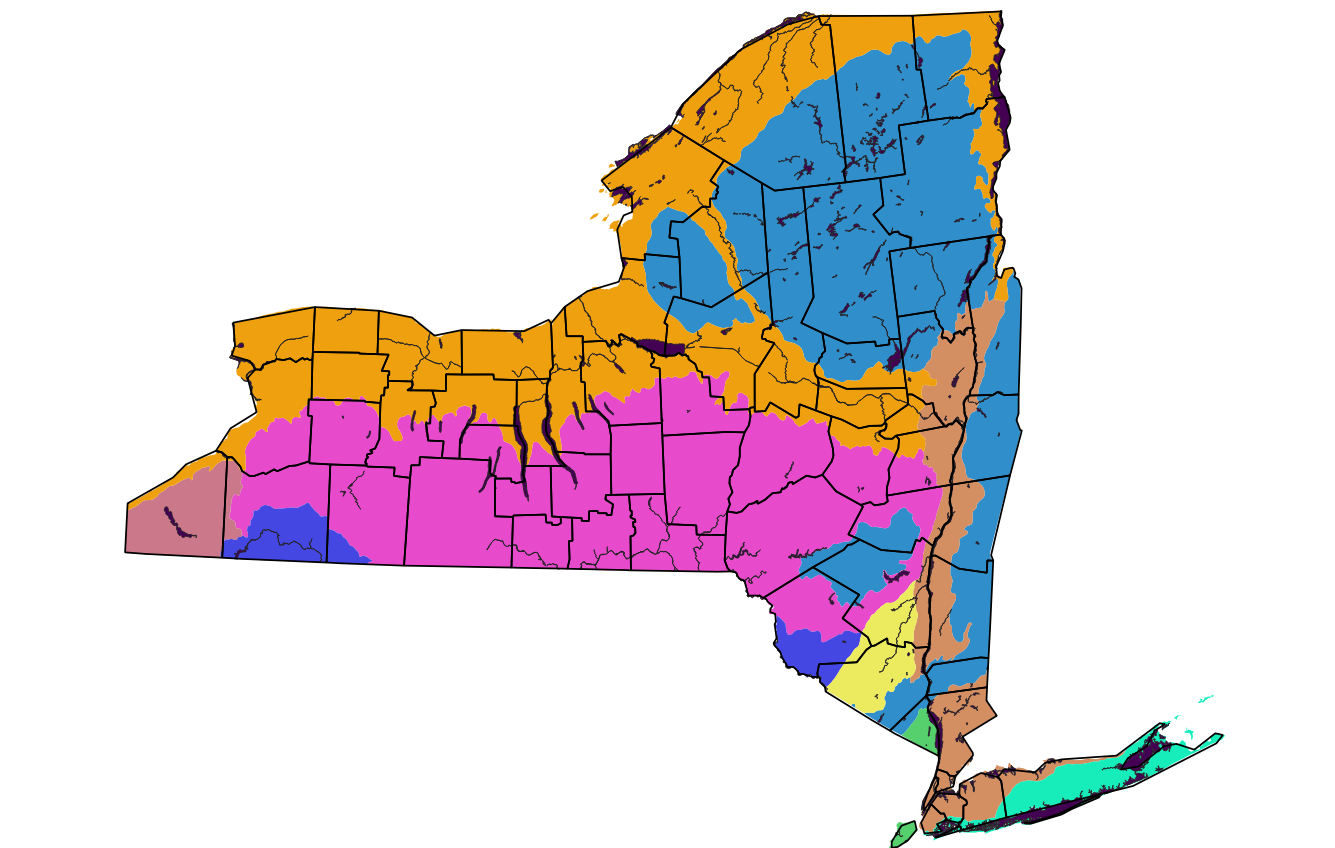
2. Ecoregions
DEC wishes to span diversity of contexts for pesticide use, in diverse upstate NY. The contract originally specified this as clusters for monitoring higher area pesticide uses in six areas, five with higher aquifer vulnerability and one with lower aquifer vulnerability. After reviewing spatial patterns of occurrence of all categories and considering the extra difficulty of spatially confined recruitment, we replaced this by: - opening up the entirety of Upstate for candidates rather than narrowing geographically early; - working at the individual site level for combinations of pesticide use and aquifer vulnerability; - bringing in ecoregions to divide Upstate New York into zones of different contexts for pesticide use.
We use the Level III Federal ecoregions, similar to bioregions mapped by DEC Fish and Wildlife. Documentation for the federal map is easily accessible. (The DEC map cites two internal DEC documents as its basis.) There are nine Federal ecoregions into which parts of New York fall, of which the first eight occur upstate: 
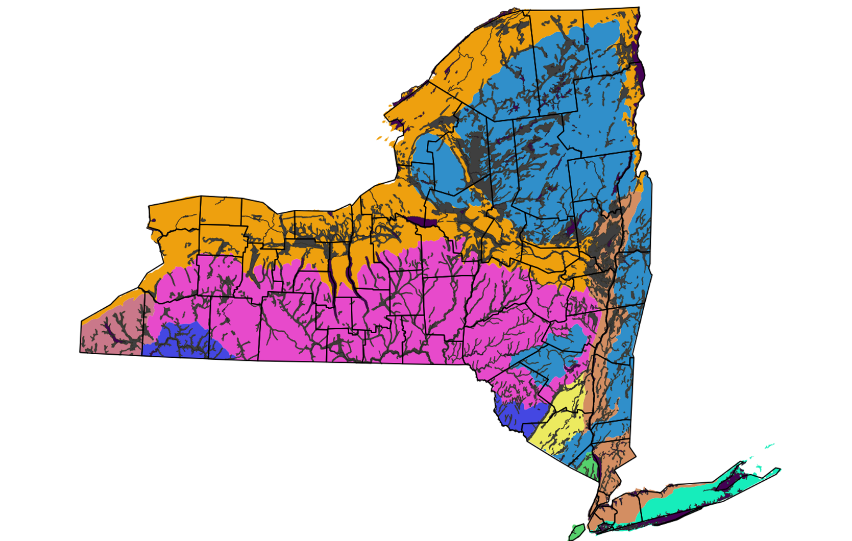
These are portrayed in Figure 1; Figure 2 adds the principal aquifers. (These are in our QGIS set at high resolution.)
3. Aquifer vulnerability:
We seek sites with expected higher concentrations of pesticides in recharge water, to be extra protective. This is affected by four factors:
- the rate of pesticides released to the environment,
- a pesticide’s mobility and persistence properties,
- the site’s propensity to deliver pesticide molecules to the water table, and
- aquifer recharge rate, providing the force to move the pesticide molecules
These factors are multiplicative. The factors are not correlated with one another directly, thus we can isolate the site vulnerability aspect (recharge and propensity to deliver) from the chemical and its release rate.
Vulnerability is affected by:
- unsaturated thickness (depth to water table),
- presence of preferential vertical flow paths (such as structural cracks),
- presence of soil layers that restrict downward flow or favor sideways flow,
- local vertical recharge rate, and
- confining or protective layers (aquitards) above the aquifer that people draw from.
Generally we are only interested in unconfined aquifers that do not have much layering of clays in the unsaturated zone.
This is very close to the NY official principal aquifer definitions and the official principal aquifer maps which are a basis for much DEC activity.
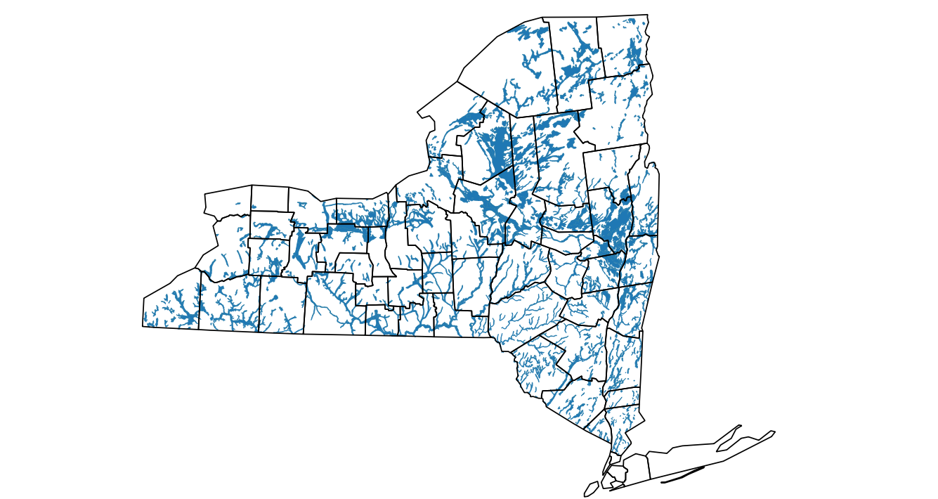
Available principal aquifer maps are coarse spatially. We can become a little more spatially precise by using the NYS surficial geology maps; their yellow colorations indicate the more vulnerable settings. We can make a site scale estimate using soil drainage classes.
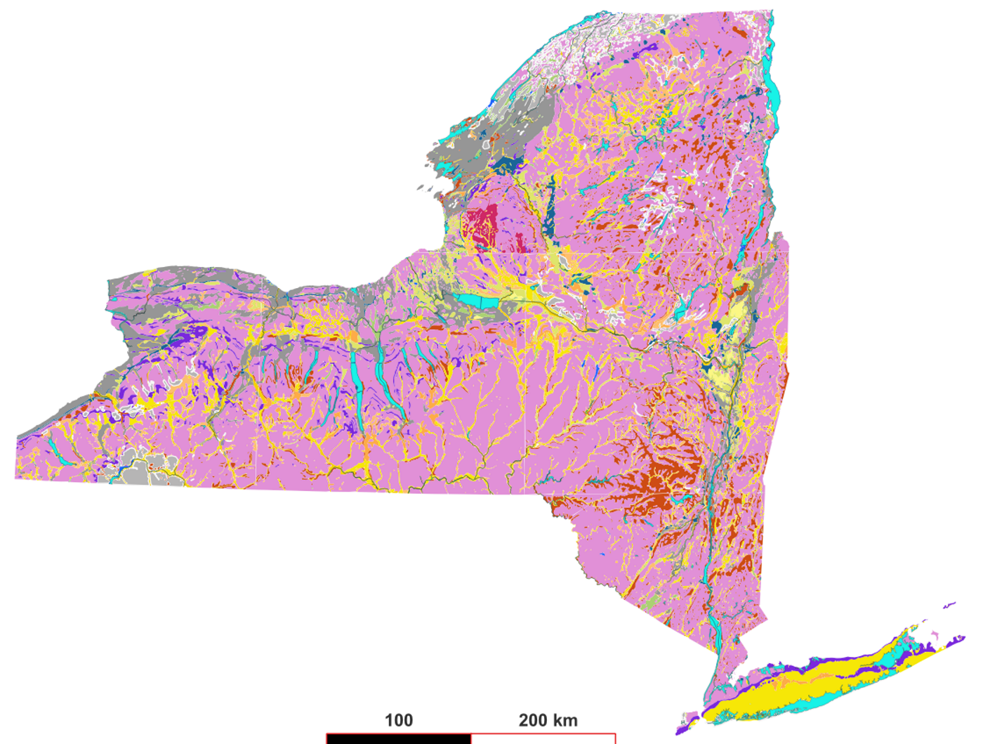

Yellow are sand and gravel types. Pink and gray are glacial till and lake silt-clay. Higher resolution than principal aquifer map.

4. Other quantitative design aspects:
- Guideline: Three wells per categorical site, one upgradient and two downgradient. These are to isolate the effects of the individual site. Some sites may need more sampling points including multiple upgradient. Some may not need upgradient.
- Two sample sets per year from each categorical site, to avoid missing seasonality. We may have to cut back to alternate years if the lab workload becomes too high.
- A limited number of new monitor wells across all sites are affordable. There were dollar and count ceilings.
- Use DEC-registered existing wells where applicable. (In practice these have been very scarce; the first 21 sites contained only one registered well relevant to sampling. Upstate water wells tend to be poor for measuring recharge quality, for the obvious reason that they are drilled more deeply to ensure that water is available during droughts.)
5. Target calendar
21 sites were recruited and sampled as of mid 2023. We may add up to three more in 2023, but the last added sites will have shorter periods of record by the end of the project in 2025.
6. Assets and liabilities for recruiting
Liabilities:
- A priori, we do not expect to find many sites that bring together all DEC criteria. This became most difficult for the sod farms which are very few in number. The design is ambitious and will need more adjustment of targets as recruiting attempts reveal problems and opportunities.
- A priori, we do not expect many people we approach to see much self interest benefit in participating. There are no deliberate incentives. We do expect some candidates to take account of their contribution to keeping pesticide labels based on objective science specific to upstate New York, as opposed to extrapolated from other locations such as very vulnerable Long Island.
- This is a pioneering effort for the Bureau of Pesticides upstate thus there will be mistakes from inexperience. This is a new kind of monitoring network, starting from pioneering work on Long Island.
- Some candidates are fearful of regulator DEC’s involvement, thus requiring extra assurance that the data collected will not be used against them. The contract’s clause requiring Cornell to disclose owner identities upon “reasonable request” by DEC is causing problems within Cornell and possibly externally; this was later scheduled to be eliminated from the contract. In recruiting we emphasized the contract’s “confidentiality” wording.
Assets:
- The Cornell Cooperative Extension network in New York maintains contact and often working relationships with many businesses in seven of the eight categories. Included in this is Cornell’s training of certified pesticide applicators which puts Cornell faculty and staff in contact with many businesses beyond the deep cooperator relationships.
- There are viticulture, turfgrass, fruit, vegetables, and greenhouse focal areas of Extension in campus and substate regions that match the pesticide user categories.
- Cornell publishes the guidance documents about pest management that many New York users apply. These documents are good guides about the array of pest problems and pesticides in recent years.
- Many candidate businesses have owners who are Cornell alumni, or have family members who attended Cornell.
- There are publicly owned, including New York State, properties that may provide reasonable sites. This should simplify some recruitment. This would include in particular the golf course and residential/institutional turf categories. (Note that our one attempt to recruit a state-owned golf course was vetoed by a State Parks contact made by DEC.)
- There were over 200 households whose wells were sampled in earlier years. All of the ones approached about resampling in earlier years had agreed. These include a few categorical site owners. Only a subset of these match the current project’s criteria, and there has been enough elapsed time for owners to die, have their telephones disconnected, or for properties to change hands. We were more optimistic than proved to be realistic.
7. Anonymous site identifiers
The tracking spreadsheet for recruiting categorical sites is the place where anonymous identifiers are created for sites. The anonymous identifier consists of a prefix string symbolizing the category, a dash, and a sequence number that reflects the order when a site became a candidate in the category. For example, “Golf-9” is the ninth candidate golf course.
These identifiers are used as lookup keys in the tabular database, thus must be unique. They are the preferred identifier to put on sample containers, hiding the actual identify from casual browsers of freezers and fridges.
8. Tracking of status
Each of the 24 sites will go through a series of stages that take it from eligible to agreement to routine monitoring. The 24 site schedules will be mostly independent of one another, though there will be logistical advantages to grouping activities like well installation at nearby sites. Multiple Cornell people may be involved at the same site. Thus there will be formal tracking needed to ensure that actions for every site occur in the right order and in reasonable time.
The tracking of a site will begin with a site record as a candidate when it first is considered worthy of contacting the owner or operator about their interest. Sites may disappear from the database if they never have the first contact because a category has enough other sites agreed.
Lakes were considered a ninth category and tracked in the same database.
The database is suitable for tactical planning, statistically updating DEC in quarterly reports, and supervision within Cornell. It begins in an Excel file stored in the project’s Box shared directory. The database is confidential from DEC. The content will be structured for future tallying of status for quarterly reporting to DEC; eventually the tallying will be automated. Only one person at a time may update the file, thus we will need to handshake by email when someone other than sp17 will be editing it.
As of March 2022 the file is edited via Box’s ability to load a Microsoft Excel file for concurrent editing in which each user sees all other users’ changes. This is through the Box website, not Box Drive.
There is a detailed description of the early communication between owner and Cornell in the HowTo for interviewing candidate categorical sites.
The various stages are, generally in order (this is evolving):
- POTENTAL. Identification of a possible site worth contacting. May be reconned without contact with owner.
- CONTACTED. Initial contact by phone.
- INTERVIEWED. Visiting interview and walkaround.
- CHARACTERIZED. Site characterization to determine groundwater flow patterns and evaluate groundwater monitoring opportunities and needs. Make its own QGIS file.
- APPROVED. Approval by DEC.
- 1STSAMPLED. Early initial sampling from existing wells.
- ALLWELLS. Installation of monitoring wells completed.
- ROUTINE. First full coverage sampling.
- Provision of interpreted lab data to owner. Include record when data received from DEC and another when sent to owner with interpretations.
- Routine sampling operation.
- CLOSED. Eventual closeout of site.
The path of a site may be terminated if a site is never contacted, is unwilling or unsuitable, or exits early. Records of early terminated sites may be retained in the tracking system.
Example of partial history log structure (site not in roster due to minimal pesticide use):
| Date | Whom | Status | Site | Comment |
|---|---|---|---|---|
| 2021 06 ?? | Sp17 | potential | DEC Tree Farm in Saratoga County | Add based on maps as easy-contact candidate for the Outdoor Nurseries category |
| 2021 06 19 | Sp17, als36 | potential | DEC Tree Farm in Saratoga County | Recon visit viewed the property from the adjacent Saratoga Spa State Park. No contact with the site personnel. |
| 2021 08 ?? | (DEC colleague) | contacted | DEC Tree Farm in Saratoga County | Called David Lee, site manager, and learned that the site does not use many chemicals. David recommended talking with Saratoga Spa State Park for their golf course, which we already have listed. |
| 2021 08 ?? | Sp17 | closed | DEC Tree Farm in Saratoga County | Site itself not eligible under the average to high pesticide use criterion. Retain contact info. They should have knowledge of the area geology and soil, and their wells (if any) might be relevant to adjacent Saratoga Spa State Park golf course if that becomes a categorical site. |
| 2021 06 ?? | Sp17 | potential | Saratoga Spa State Park golf course | Add based on maps as an easy-contact candidate for the golf courses category. |
| 2021 06 19 | Sp17, als36 | potential | Saratoga Spa State Park golf course | Recon walk and drive around the park. Park has much landscaping and perhaps could be considered for residential/institutional turf category as well. Saw excavation on golf course which looked quite sandy. Will discuss golf course with Frank Rossi. |
The actual (confidential) log is in Box: DEC/Site Recruiting Progress 2023.xlsx . The actual structure is in Excel to allow sorting, excerpting, and drilling down from overview to detail. Not that this tracking list is not edited to preserve confidentiality, so the whole list must be treated is confidential. We make summary, redacted snapshots for quarterly and annual reporting.
There will also be entries in the field log about these sites that are actually visited. See the field logging howto.